GEOKON SiteMaster Inclinometer Data Reduction Software GK-604-8 (Electronic Delivery)
Price: Contact
Brand: Geokon Vietnam
Category: Thiết bị quan trắc
Supplier: AnhNghiSon
Origin: USA


 0911472255
The GEOKON Model GK-604-8 SiteMaster Inclinometer Data Reduction Software, provided and licensed by GEOKON, INC. (Lebanon, New Hampshire, USA), is the global industry-standard software application for post-processing, algorithmic data reduction, and reporting of borehole inclinometer survey datasets.
Electronic Software Fulfillment Architecture (NOT SHIPPED - Delivery via Email):
The GK-604-8 product code represents an Electronic Software Download (ESD) license:
- Completely eliminates physical parcel freight and international customs transit delays (NOT SHIPPED).
- The official software installation package alongside the validated digital License Authorization Key is dispatched directly to the designated client email address (NOTE: specify email address for download), enabling immediate deployment, registration, and project workflow continuation.
Comprehensive Data Reduction & Analytical Capabilities of SiteMaster (GK-604-8):
Acquiring field inclinometer surveys represents only the primary stage of subsurface monitoring. To present defensible compliance data, raw field logs must undergo rigorous reduction to eliminate survey errors caused by casing grooving spiraling, probe sensor bias, or mechanical settlement. SiteMaster delivers complete end-to-end analytical control:
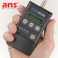
- Universal Hardware Data Interoperability: Seamlessly imports data directly from GEOKON FPC-1 and FPC-2 Field PCs paired with GK-604 and GK-604D systems. Additionally, SiteMaster imports text-based datasets (.csv, .dat, .txt) produced by any commercial inclinometer system on the market.
- Automated Checksum Logic Scanner: Evaluates survey check-sums (A0 + A180 and B0 + B180 combinations) across all survey depth increments. Discrepancies resulting from tracking errors or probe positioning mistakes are automatically highlighted with intuitive visual alert colors.
- Advanced Algorithmic Correction Engines (Correction Options):
+ Spiral Survey Correction: Integrates digital compass logs to mathematically rotate deflection vectors, eliminating azimuth errors caused by spiraled casing.
+ Bias Shift Correction: Normalizes long-term sensor zero drift across multi-epoch surveys.
+ Rotation Correction: Corrects angular offsets between probe guidance wheels and internal accelerometer sensing axes.
+ Base Shift Correction: Compensates for lateral translation when the casing toe is not anchored into solid bed rock.
- Structured XML Project Database (Smart Data System): Efficiently manages multi-borehole projects, georeferenced site plans, geotechnical borehole logs, and excavation chronology in systematic folders.
- Dynamic Graphical Visualization: Generates publication-quality plots of Cumulative Deflection, Incremental Deflection, Absolute Profiles, and Time-Displacement curves at critical elevations, overlaid with multi-level safety warning thresholds.
- One-Click Engineering Report Generation: Features a robust reporting engine exporting structured summary logs, graphs, and statistical variance tables into Microsoft Word (.docx) and Adobe PDF files ready for engineer-of-record submission.
Target Industrial Sectors & Applications:
- Deep Urban Excavations & High-Rise Basements: Monitoring lateral deflection of diaphragm slurry walls, secant piles, and braced sheet pile walls adjacent to sensitive urban structures.
- Metro Lines & Subterranean Tunneling: Convergence monitoring and lateral ground movement tracking surrounding Earth Pressure Balance (EPB) / Slurry TBM drives.
- Embankment Dams, Tailings & Water Reservoirs: Structural deformation profiling for earthfill/rockfill dams and perimeter tailings retaining dikes.
- Highway Infrastructure & Unstable Slopes: Slope stability evaluation, deep shear zone localization, and landslide mitigation.
- Geotechnical Testing Laboratories & Academic Institutions: Verification of finite element numerical modeling against real-world displacement measurements.
• Software Developer / Licensor: GEOKON, INC. (in collaboration with Deep Excavation LLC)
• Country of Origin: 100% USA (Made in USA)
• Software Program Name: SiteMaster Inclinometer Data Reduction Software
• Product Order Code: GK-604-8
• Unit of Measure: Software License (Unit: Software)
• Fulfillment Method: Electronic Software Download (ESD / NOT SHIPPED) - License delivery via user-specified email
• Inclinometer Data Compatibility:
- Direct import from GEOKON GK-604, GK-604D systems (Field PC handheld files)
- Universal text-based data parser supporting any third-party system (.txt, .csv, .dat formats)
- Manual data spreadsheet entry mode
• Comprehensive Data Reduction & Error Filtering:
- Color-coded Checksum Logic Scanner identifying anomalous survey intervals
- Spiral Survey Correction (compensating for casing rotational twist)
- Accelerometer Bias Shift correction
- Probe Alignment Rotation correction
- Probe Constant calibration adjustment
- Base Shift correction (for unanchored casing bottoms)
• Graphical Analysis & Plotting Outputs:
- Cumulative Displacement Profiles
- Incremental Displacement Profiles
- Absolute Casing Profiles
- Time-Displacement History graphs at user-selected depths
- Plan View Vector displacement plots overlaid onto scaled site plans
• Construction Chronology Integration: Links displacement curves directly against excavation depths, tieback pre-stressing stages, and groundwater fluctuations.
• Automated Limit Alarming: Configurable displacement and velocity thresholds highlighted with dynamic warning colors (Yellow, Orange, Red).
• Report Generation Engine: Direct export of comprehensive reports into Microsoft Word (.docx) and Adobe PDF.
• Data Management Architecture: XML-based Smart Data System allowing data folder backups via standard Windows Explorer.
• Measurement Units Supported: Seamless toggling between Metric (m, cm, mm) and Imperial (ft, inches).
• MINIMUM SYSTEM REQUIREMENTS:
- Supported Operating Systems: Microsoft Windows 11, Windows 10, Windows 8, Windows 7 (32-bit & 64-bit platforms)
- System RAM: 512 MB minimum (4 GB or higher strongly recommended for multi-borehole projects)
- Hard Disk Space: Minimum 60 MB available hard drive space for installation
- Display Resolution: Minimum 1024 x 768 pixels or higher.